

SEATTLE — A rain-snow mix fell over parts of western Washington early Monday morning, with some areas of Whatcom County recording up to 3.4 inches of snow.
The county is still recovering from record flooding in November that caused millions of dollars in damage to cities like Everson and Sumas.
Washington State Department of Transportation (WSDOT) traffic cameras showed light snow accumulation on I-5 from Bellingham to Blaine around 5 a.m. Monday.
The National Weather Service (NWS) shared a graphic Monday morning showing snow totals from the Community Collaborative Rain, Hail and Snow Network. Whatcom County received between 0.5 and 3.4 inches of snow by 10 a.m. Monday. Areas around Bellingham received between 0.5-1.5 inches of snow, while 3.4 inches of snowfall was reported in Sumas.
Some western Washington schools ran on a two-hour delayed start Monday morning due to the winter conditions, including the Lynden, Mount Baker, Ferndale and Meridian school districts. Click here for a list of school delays.

The system is expected to bring 4-6 inches of snow to Stevens and Snoqualmie passes Monday. A live stream from the Summit at Snoqualmie showed steady snow falling at 4 a.m. Click here to check WSDOT pass reports for the most up-to-date information.
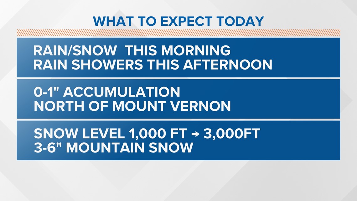
Snow levels are expected to rise to 3,000 feet Monday afternoon. Rain is expected to taper off Monday evening.
Tuesday is expected to be warmer and mostly dry, with some lingering moisture in the Cascades and Olympics.
Another system will move into the area Tuesday night into Wednesday, bringing rain to the lowlands, mountain snow and breezy winds. The NWS said snow levels are expected to lower to around 1,000-1,500 feet Wednesday night, with another 8-12 inches of snow possible across the Cascade passes.
Throughout this period, high temperatures are expected to be in the low to mid-40s with lows in the 30s, which is cooler than normal for the Puget Sound region at the beginning of December.
On average, Seattle-Tacoma International Airport typically records its first measurable snow of winter on Dec. 16, according to weather service data.
