SEATTLE — An amplified weather pattern is sending chilly air and increasing chances of lowland snow in western Washington.
The setup
Chilly, well below-average air is building near the North Pole. This air is currently bottled up but a piece of it will break off, moving south toward the lower-48 of the United States.
The coldest air will stay east of the Pacific Northwest, but a sliver of the cold air will find its way into western Washington beginning late Sunday, sticking around through much of next week. Temperatures will run nearly 10 degrees below average for highs.
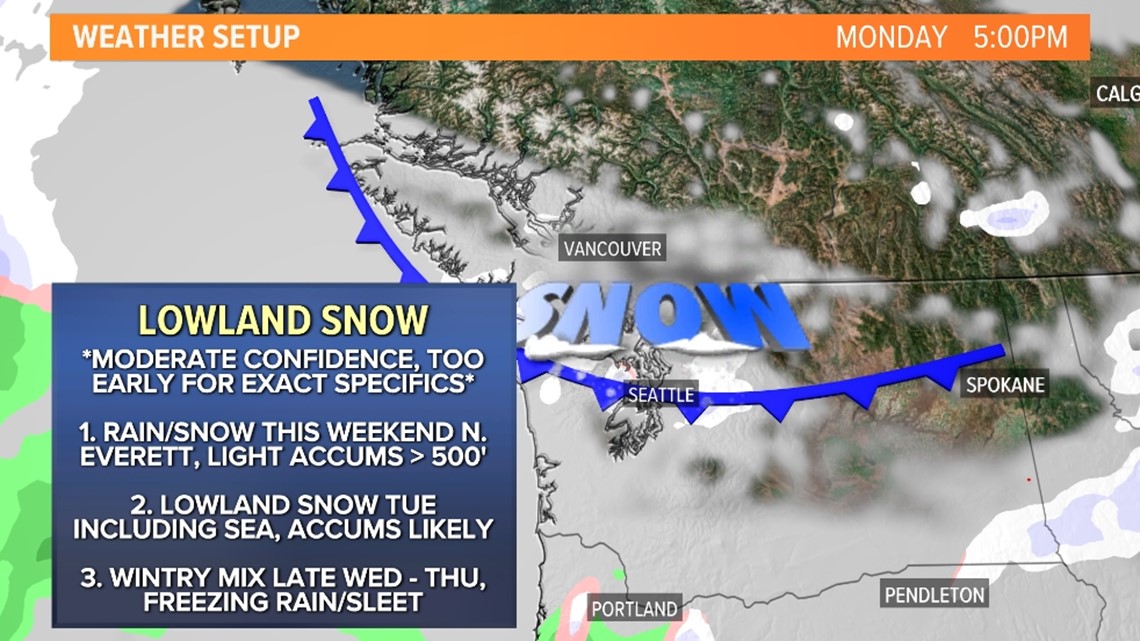
At the same time, a few small disturbances will move off the Pacific Ocean toward the area bringing lift and moisture into the cold air, setting the stage for a few lowland snow opportunities beginning late Saturday and continuing through much of next week.
Some accumulations are possible, which could lead to some travel disruptions on roadways and at airports.
Timeline
Sunday
The first opportunity for wintry weather arrived late Saturday mainly for Whatcom, Skagit and San Juan counties above 500 feet. Snow levels look to fall as low as sea level by Sunday as the Fraser Valley allows colder air to filter into Whatcom County.
A Winter Weather Advisory has been issued for this first round of winter weather. For the lowlands of western Whatcom County (including Point Roberts, Lummi Island, Bellingham, and Sumas), the advisory ends at 4 p.m. Sunday. For the Cascade mountains and valleys of Snohomish and King Counties, the advisory continues until 10 p.m. Sunday.
A Wind Chill Advisory is also in place from 7 p.m. Sunday to 10 p.m. Monday for the lowlands of western Whatcom County (including Point Roberts, Lummi Island, Bellingham, and Sumas) with wind chills as low as 10 below zero.
The wintry mixture will extend farther south into Snohomish, King and Pierce counties above 1,000 feet on Sunday.
Light accumulations of up to 1 to 2 inches are possible mainly for Whatcom and Skagit counties.
Sunday evening radar


Monday
Colder air moves deeper into the Puget Sound lowlands dropping snow levels for Snohomish, King, Pierce, Thurston, and Kitsap counties on Monday. Snow levels will fall to around 500 feet for locations south of Everett with snow levels falling to 200 feet north of Everett. Whatcom County should see snow levels stay near sea level on Monday.
With the colder air and dropping snow levels, moisture begins to drop off too. Only spotty lowland snow showers are possible across the area on Monday with minor, light accumulations for areas that see the spotty snow showers.
Monday evening radar

Tuesday
Additional moisture arrives on Tuesday with the cold air still in place, increasing snow chances for all of western Washington. Snow levels will hover around 200 feet south of Everett and near sea level north of Everett. Despite snow levels being around 200 feet near Seattle, any heavier precipitation that develops could drop the snow levels to sea level in the Seattle metro on Tuesday.
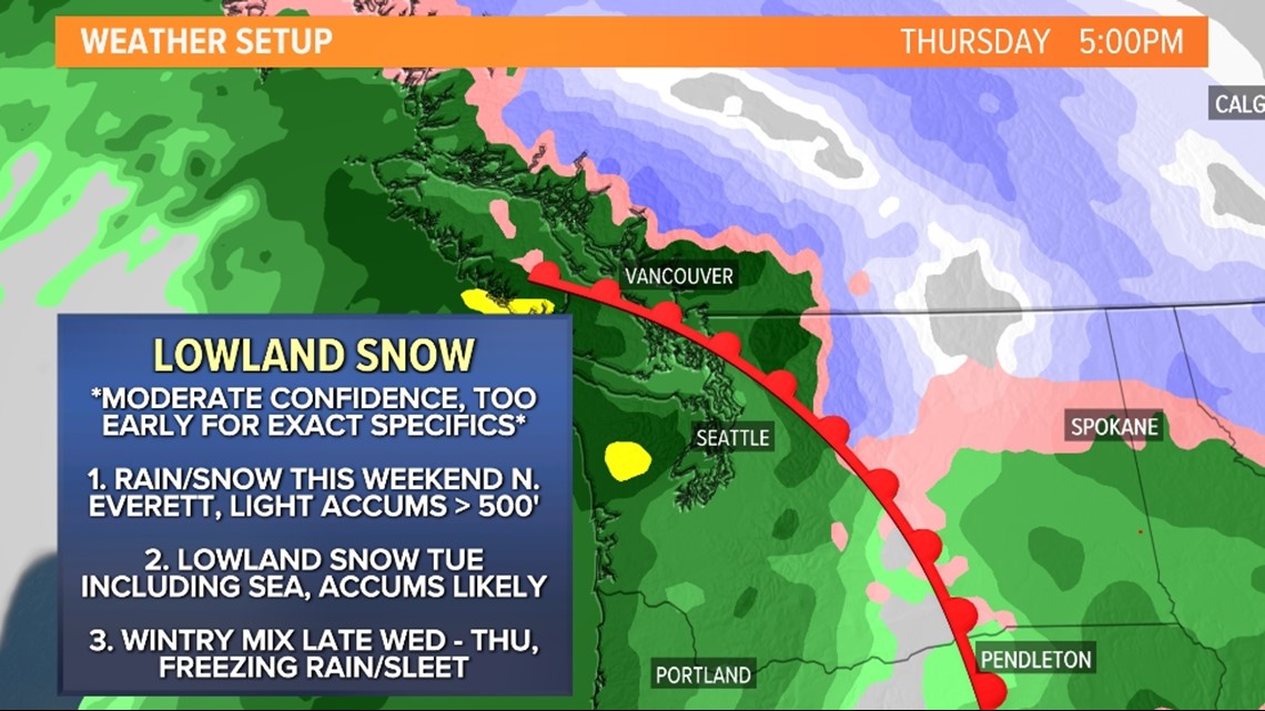
Snow looks to be widespread and potentially moderate at times leading to accumulations. It's too early for specifics on accumulations but it does appear a few to several inches could fall for some lowland areas away from water, favoring Whatcom County and the Kitsap Peninsula. Some accumulations are also possible in or near Seattle, Everett, Bellevue, Tacoma, and Olympia.
Tuesday evening radar


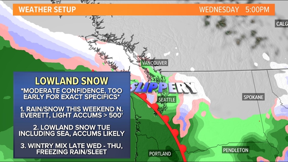
Wednesday to Thursday
Wednesday into Thursday looks to be a transition day as another system approaches, pulling in a warm front late Wednesday. This will increase the moisture and begin to increase the temperatures too.
A wintry mixture of rain, freezing rain, sleet, and snow are possible for parts of the Puget Sound lowlands Wednesday evening into Thursday morning. This forecast is a little complicated as it's far out but South and Central Sound could see snow transition to freezing rain and eventually rain throughout Wednesday night.
Farther north for the North Sound, snow is forecast Wednesday night into Thursday morning before transitioning to a wintry mixture throughout the day Thursday to all rain by late Thursday as temperatures continue to rise.
Snow and ice accumulations are highly uncertain during this timeframe.
Wednesday evening radar

Thursday evening radar

Accumulations
The event is still a few to several days out so there's lower confidence in the accumulation forecasts and it's too early to pinpoint exact accumulations but some accumulations are expected.
The favored areas to see snow accumulations are in Whatcom, Skagit, and San Juan counties late weekend. Eventually, parts of the Puget Sound lowlands and the Kitsap Peninsula, including Seattle, Everett, Bellevue, Tacoma, and Olympia see accumulations on Tuesday. Area roadways and airports could see at least minor travel disruptions.
The mountain passes will see at least several inches of snow beginning late Saturday with additional snow accumulations throughout next week. This could disrupt travel so check the latest pass conditions before traveling over the mountains for the holidays.
This is a fluid forecast and subject to change so keep checking back as the KING 5 First Alert Weather Team continues to finetune the forecast over the coming days.