
Western Washington’s record snowfall may have wreaked havoc on roads and school schedules, but it gave the state’s snowpack a huge bump, jumping from 74 percent of normal at the beginning of the February to 91 percent of normal on Friday.
Most of that increase came between February 8 and 12 when nearly a foot and a half of snow fell in western Washington. The Cascades also got pounded, including Crystal Mountain, which got 7 feet of snow in seven days.
“If this were baseball, you could say we just had a five-run inning,” Jeff Marti, Washington Department of Ecology water resources drought coordinator, wrote in a blog post.
Snowpack is a significant water supply for the region, helping feed rivers and streams and providing a source for hydroelectric power.
Washington’s snowpack now contains 30 million acre feet of water, including 8 million that were gained between February 5 and 20. An acre foot of water is equal to the volume of water spread over one acre that's one foot deep. To put it in perspective, that’s nearly the amount of water stored behind Grand Coulee Dam, the state’s biggest constructed reservoir.
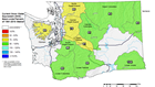
As of Thursday, the Lower Snake and Lower Yakima regions led the state in snowpack, recording levels that were 104 percent and 99 percent of normal, respectively. South Puget Sound (96 percent) closely followed.
However, the North and Central Puget Sound regions still have some of the lowest snowpack in the state, registering at 86 percent and 78 percent, respectively. The Central Puget Sound region feeds the Green-Duwamish, Lake-Washington/Cedar, Snoqualmie, and Skykomish basins, according to the Department of Ecology.

The good news is temperatures have been cooler than normal – February is on track to be one of the coldest ever recorded at Sea-Tac Airport – which helps preserve the snowpack and keeps it from melting early.
Snow season typically ends around early April, which means there’s still time to jump up to normal levels. However, the department says chances that we will reach normal diminish the closer we get to April and stay below normal.
Even though Washington’s snowpack made huge gains this month, it’s still ranked 14th lowest in the last 30 years and is lower than we were at this point in 2018, 2017, and 2016, according to the Department of Ecology.
Officials hope Mother Nature cooperates for the last few weeks of winter as long-range climate predictions indicate Washington could be facing a warmer and drier summer than average. A report released Thursday from the national Climate Prediction Center says there’s a 50 percent probability Washington will have a warmer summer than usual and a 33 percent chance of a drier summer than normal.