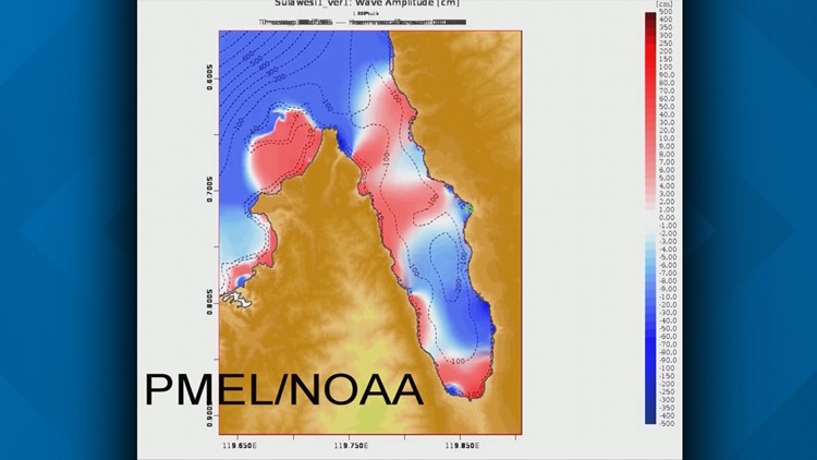
New animation produced by the Pacific Marine Environmental Laboratory in Seattle is giving us our first scientific look at the tsunami that has ravaged parts of Indonesia.
The animation, which is an original version based on the available facts, shows energy trapped inside of a long fjord-like bay, ricocheting off the east and west shorelines, with the City of Palu at the south end.
The height of the tallest tsunami wave is estimated at 6 meters, or about 20 feet, which devastated parts of the city, leaving ships marooned on shore. The tsunami was triggered by a magnitude 7.5 earthquake and caused more than 1,500 deaths, a toll that may continue to rise.
The animation was produced by Vasily Titov, who is the lead scientist for tsunami research for PMEL, which is part of the National Oceanic and Atmospheric Administration.
"Nature has a tendency to surprise us at the wrong time in the wrong place,” says Titov, who feels for the victims in a country he has visited multiple times while performing previous tsunami research.
He says his computer model was greatly aided by video taken from the cockpit of an airliner which took off as the earthquake started. The plane is flying over the bay, and the video shows water lifting up in places along the shoreline like a hump or a hill.
Inside the raised water, you can see white water churning, suggesting the shaking triggered underwater landslides, known to have caused tsunamis in the past. It’s the first time he believes the birth of a tsunami has ever been caught on camera.
What has the attention of Titov and other tsunami experts, is the tsunami is associated with a type of earthquake that doesn’t usually trigger large waves. Classic coastal tsunamis killed 15,000 in northeastern Japan in 2011, and the worst in recent history killed 250,000 people in 2004 around the Indian Ocean, including Indonesia.
These classic coastal tsunamis are caused by faults where one side of the fault is offset vertically from the other. Typically one side is lifted up or dips down, shifting the bottom of the ocean and driving energy into the water above. In the Palu earthquake, evidence is that the fault didn’t do that, but slipped side-to-side, which usually doesn’t trigger a tsunami. So what happened?
“How exactly it was generated, we still don’t know,” says Titov. “This is one piece of the puzzle we’re looking at right now.”
He expects a team of tsunami experts from around the world will be visiting the area in the weeks ahead to find more quantifiable evidence, including wave heights, how far the waves reached inland, and underwater evidence of landslides.
The analogy is that of a bathtub or water contained in a bucket or any contained space. Simply moving the bathtub or bucket results in water sloshing up the sides. Add to that the complexity of the shoreline which can concentrate water, causing it to resonate may have been one of the key contributors to the tsunami. The horizontal shifting may have played a large role in how the tsunami played out.
But here’s the thing, for Titov, there is a troubling comparison to Puget Sound, or even large bodies of fresh water such as Lake Washington or Lake Sammamish.
“Our setting right here is very similar to what we see in Palu, in terms of the geometry and geography of the bay,” Titov says. “We are working quite intensively on tsunami hazards, on estimating tsunami hazards on Puget Sound. This puts the problem on the front line.”