SEATTLE — What will fall be like this year? Cold and wet or warm and dry?
We’re going hyper-nerdy right off the bat by invoking Sir Isaac Newton and his laws of motion in physics. His Third Law of Motion states that: “For every action, there is an equal and opposite reaction.”
Why is this relevant? Because as it pertains to the summer that we just experienced here in the Pacific Northwest, it’s hard to deny that it was marvelous. No triple-digit heat waves, relatively mild wildfire haze and a summer that was bookended by a marvelous start and a warm, sunny finish.
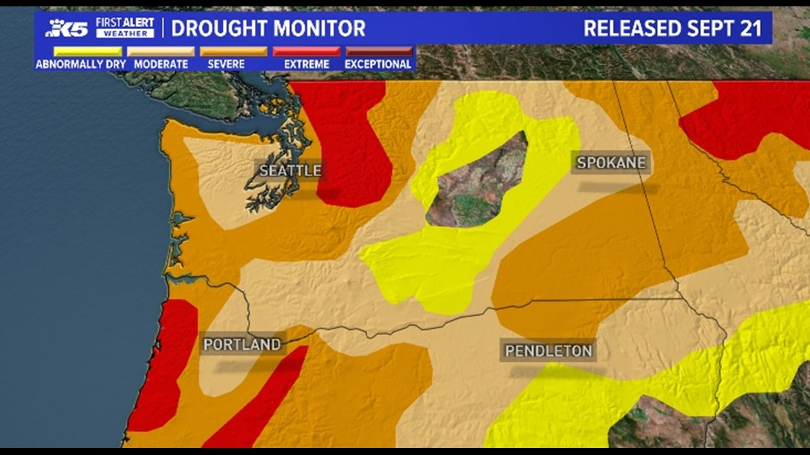
But there was a trade-off. It was DRY. We saw drought conditions steadily worsen, especially over the northern Cascades. Although we had some wildfires here, our neighbors in Oregon, Northern California and British Columbia were very active.

It was also relatively mild here compared to other parts of the country. And the earth itself was hot. Like really hot.
Summer of 2023 was Earth’s hottest since global records began in 1880, according to scientists at NASA’s Goddard Institute of Space Studies (GISS) in New York.
Phoenix, Ariz., broke a weird record with a temperature of 110º or hotter every single day from June 30 to July 30 (insert Newton's Third Law here – they suffered while we basked).
That helps set up our Fall forecast here. We got away lucky this summer, but we need rain and snow in a big way.
Will we get it? Statistically, it’s not looking good. After three winters of La Niña conditions, we’re now flipping over to an El Niño winter. People’s eyes glaze over when we start talking about ENSO cycles, but in very general terms, El Niños tend to favor the southwest and keep the northwest warmer and drier than normal.
But! It’s an observation, not a law. Take the incredible amounts of rain and snow observed last winter and spring over the Southwest – which was during a La Niña, when statistically they’re the ones who are supposed to be warm and dry.
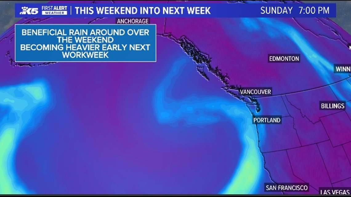
As we enter the first days of fall 2023, we’re looking at a significant pattern change that features our first atmospheric river event, so at least it’s starting on a positive note.

What is the 3-month outlook from the Climate Prediction Center on temperature and precipitation?
If you enjoy mild conditions, you’re in luck. NOAA’s Climate Prediction Center is estimating that there is a 50 to 60 percent chance that the PNW’s temperatures will run above average. They’re also saying that our precipitation outlook is leaning toward being below average over the next 90 days.
A continuation of El Niño is extremely likely this Fall and Winter, with over a 95 percent chance through January-February-March. Additionally, a strong El Niño is likely by late Fall and early Winter, with approximately a 70 percent chance of occurrence during the November-December-January 2023-24 season.
How does this outlook compare to Seattle normal rain totals/temperatures? How much of a diversion from normal is that?
Washington state has several microclimates, so for the purposes of our story, let’s just stick with Sea-Tac. Most cities use their airports as the “central” record keeping spot, and we’re no exception.
It’s difficult to say numerically how far off “normal” we’ll be. Typically, this is our busy season, with October, November and December capturing over 40% of our annual rain totals. We’d need about 16 inches during that timeframe just to be average. Anything above that would help us catch up on our deficit. Anything below that spells trouble going forward.
Mean average temperatures run about 54 degrees in October, 47 degrees in November and 42 degrees in December. It would be nice if it weren’t this cold, but we need cold air to help build snowpack – the most important element in drought fighting and wildfire mitigation.
When does rain/stormy weather normally pick up in Seattle and can we expect that this fall?
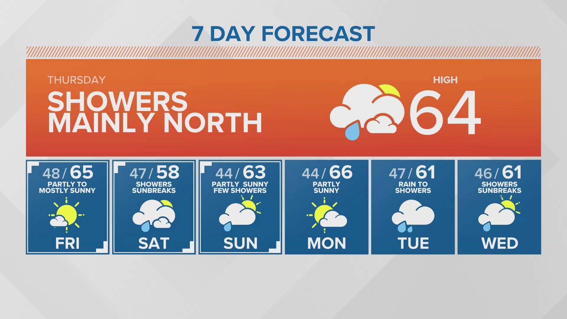
October through April are typically the most active months here, with a big difference between September and October, when we go from an average rainfall of 1.61 inches in September jumping to an average of 3.91 inches in October.
Although the coming week is looking promising with 1 to 3 inches possible, we simply don’t know if that trend will continue.
November is the wettest month - will that be the case this year?
November is king! With a normal of 6.31 inches, it beats December and January, which typically average 5.72 inches and 5.78 inches respectively. With an El Niño on tap, we might not get that initial big storm like we have over the past couple of years. It could be a mixed blessing – no major river flooding but also less water landing in our reservoirs.


Fall storm outlook: Is there a way to predict if it will be a bad windstorm or flooding year?
Climate is what we expect. Weather is what we actually get. That said, we expect this fall and winter to be warmer and drier than normal. That does not rule out the possibility that we could see any major storms that deliver flooding rains and/or damaging winds.
El Nino impact: What is El Nino and how is that playing a role this fall?
You may have heard us mention the jet stream during our forecasts. The jet stream is the upper-level wind pattern that delivers colder and wetter air as it navigates its way through the labyrinth of high and low pressure systems that are present at any given time.
El Niño typically sends the jet stream, and therefore winter storms, into the southwest, leaving the Pacific Northwest high and dry – at least in relative terms. These winters often feature low precipitation and mild winters in the Pacific Northwest, sometimes resulting in a poor mountain snowpack.


Long-term impact: We're already behind in rainfall for the year. Do we have a chance to catch up?
Of course! In sports, even when one team is expected to soundly beat another, they still must actually play the game in order to prove it. Weather is the same. It would be delightful if we filled up the reservoirs and had a terrific snowpack build up this year, but the odds are against it.
Although a mild winter might be pleasant in the short-term, the long-term impacts could be rough. Water restrictions, increased wildfire dangers and damage to our already fragile ecosystems may be waiting for us next spring and summer.