
WASHINGTON, USA —
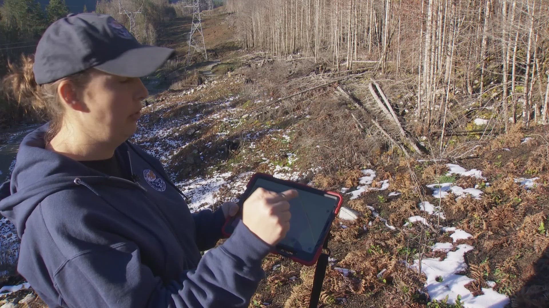
Kate Mickelson climbs up large boulders that follow a stream. Along the side of the water, ashy stumps are scattered around, marking the devastation that hit the area a little more than one year prior.
Mickelson is walking through the Bolt Creek burn scar. The fire started in September of 2022 and burned just shy of 15,000 acres north of Highway 2 in Washington, about halfway between Seattle and Stevens Pass.
Kate works for the Department of Natural Resources as the manager of the Landslide Hazards Program for the Washington Geological Survey. Her job is to monitor this area, among others in the state, for the new risk that now looms after the fire: debris flows.
She describes debris flows as a landslide triggered by heavy rain and can move 10 to 30 mph downstream, usually following the path of a waterway, while picking up large boulders and debris along the way.
“During even a modest rainstorm, all that water that used to be soaked into the ground now slides and runs off kinda like it’s on a Slip 'N Slide,” she said.
There’s a metric they use to predict when these natural disasters can happen. The USGS watches rainfall over burn scars, considering burn severity and slope of the land. If a threshold of about a quarter of an inch of rain in 15 minutes or one inch of rain in an hour hits, they message that there is an increased risk of debris flows. The National Weather Service is a key player in those alerts.
But Kate and her team think this setup has an issue: The data used is based on modeling from California. They think that, in the northwest, that might be different because of differences in climate and geology.
"That modeling was developed and tested for Southern California, which is very different than our climate up here in the Pacific Northwest,” she said.
She and her team have been monitoring burn scars in Washington since 2021 and, since then, have cataloged 119 debris flows and flooding events in nine different burn scars across the state.
Their goal is to analyze debris flows and look at where they happen and the rainfall rate at the time of the incident, then have a better idea of the threshold.
"We’re trying right now to answer two fundamental questions: How much rainfall does it take to trigger debris flows in these burn scars and how long are these areas at risk following a fire?” said Kate.
In the Bolt Creek burn scar, they installed three weather stations at the end of 2022 that will gather and share current weather data in real time.
This is a huge upgrade compared to their old system of tipping bucket rain gauges, which were inefficient for this current goal. The tipping bucket data had to be manually collected and it’s impossible to tell when the rain fell at a specific time during the day.
"This issue with that is we can’t see in real time how much rainfall is occurring and we have to go out and physically download the data. Whereas these, these are on the internet. They’re publicly available; anyone can see the data login and see how much rainfall is occurring,” said Kate, standing in front of one of the new weather stations.
The weather stations know exactly how much rain is falling by the minute, and the second piece of key data they need is matching that with when a debris flow occurs.
For that, they installed cameras within the burn scars, strategically placing them in a place that overlooks a likely spot for a debris flow but that wouldn’t get swept away in it. The Bolt Creek camera was installed in May of 2023.
The real-time weather data and visuals of the regions are exactly what they need to fine-tune the debris flow prediction metric.
"This is helping us with that timing piece. As the debris flow comes down, the camera will trigger and take a series of photos or video and then we can get that exact time that the debris flow occurred and correlate that with our weather station data,” said Kate.
They’ve already captured debris flows in other parts of the state. One camera in the Cedar Creek burn scar captured a debris flow.
Sequence of debris flow at Cedar Creek burn scar

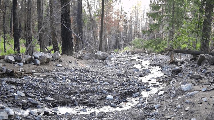

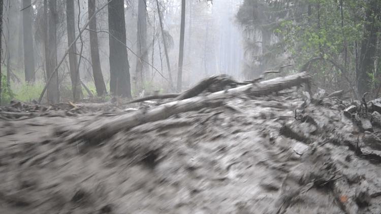


"We have photos from before and after the event and seeing the wall of water and material go so quickly is really impressive,” said Kate, looking at the images.
In the meantime, the Washington State Department of Transportation (WSDOT) is working proactively to install fencing along a stretch of Highway 2 that they believe would have the highest chance of spillover onto the road if a debris flow should occur.
WSDOT transportation engineer Kately Card walks the project as workers pour cement and points out why this spot would be an issue.
"Debris flows are channelized, so they usually follow existing channels. That's why we predicted that it’s possible to come down here,” said Katelyn, pointing to the culverts.
She then pointed to the new metal fences, noting one will be 110 feet long and one will be 60 feet long. There’s also a berm a few yards away.
"So that’ll be able to catch that debris that comes down in a debris flow and allows this water to pass. If larger debris were to come down, it would clog up the culvert and it would be overwhelmed and we’d have water on the highway,” said Katelyn.
While WSDOT works preventatively, DNR is working on the research side. DNR is hoping to expand and hire more people to analyze the data they’re now gathering, and in the Governor’s supplemental 2024 budget, the post-fire debris flow program is fully funded.
Kate said it could take years to fine-tune the debris flow metric system, because they need to wait for debris flows to occur to have something to analyze and better understand the threshold.
DNR recently launched a dashboard that shows the Bolt Creek burn scar and the areas more likely to see a debris flow.