
SEATTLE — By now you've probably heard the term "atmospheric river" and "Pineapple Express" or even know what one is.
Atmospheric rivers are not unusual in Washington or along the west coast during the fall and winter seasons.
These atmospheric rivers are responsible for up to 50% of all rainfall on the west coast.
There's the potential for two weak atmospheric river events to bring areas of moderate to heavy precipitation to parts of western Washington over the coming days.
RELATED: Western Washington Forecast
The first round of heavy rain associated with the first atmospheric river arrived Wednesday night for the far northwestern parts of Washington. The northern tip of the Olympic Peninsula saw the most moisture aimed at that area Thursday, slowly shifting south across the Olympic Peninsula into the Northwest Interior throughout the day.
The weather system not only brought rain to the region but also winds with gusts up to 45-50 mph in some areas.
The National Weather Service issued a Wind Advisory for areas of the north coast until 5 p.m. Thursday. A Wind Advisory was also in effect until 8 p.m. Thursday for San Juan County and western Whatcom and Skagit counties, including Everett and the Admiralty Inlet area.
The weather service said the strongest gusts are expected near the water, “especially near Whatcom County and Admiralty Inlet.”
What is an atmospheric river?
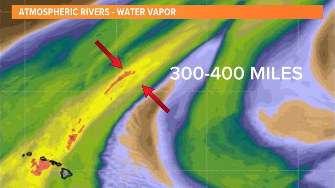
An atmospheric river is a narrow band of moisture fed over the ocean that transports high amounts of atmospheric moisture from the mid and lower latitudes.
It's a very similar process to the flow of water in a river, resembling a river on satellite imagery. This is the very reason it was coined an atmospheric "river" in the 1990s by scientists.
These narrow feeds of moisture are generally 200 to 400 miles in width but can extend for several hundred or even thousands of miles in length, carrying as much water as the Mississippi River in 24 hours. That's around 400 billion gallons!

In extreme cases, atmospheric rivers can carry as much water as two Amazon Rivers in a 24-hour period, which is roughly 10 trillion gallons of water.
While atmospheric rivers and Pineapple Expresses both bring high amounts of atmospheric moisture to western Washington, there's a difference between the two.
A Pineapple Express is a river of moisture in the atmosphere that flows from areas near Hawaii to Washington or anywhere along the West Coast. As you can imagine, the air coming from such equatorial regions has warmer and moister properties, which can enhance the precipitation totals and send snow levels skyrocketing to higher levels than you'd typically expect during the cool season.
All Pineapple Expresses are atmospheric rivers, but not all atmospheric rivers are Pineapple Expresses. Try saying that two times fast!
Pineapple Express and atmospheric rivers are commonly associated with heavy precipitation. Once the atmospheric river encounters the coast of Washington and starts encountering the higher terrain, this is when the moisture is forced out of the atmosphere into lowland rain and mountain snow.


Atmospheric River Scale
Like hurricanes and tornadoes, there's a scale to categorize the strength and associated impacts of an atmospheric river event.
The Atmospheric River Scale helps categorize an atmospheric river's impacts by quantifying the amount of moisture in the atmospheric river and the duration the atmospheric river will stay over a particular area.
The scale is a five-category scale ranging from Category 1 (weak) to Category 5 (exceptional). Weak atmospheric rivers bring beneficial rain to the region whereas exceptional atmospheric rivers can bring feet of lowland rain and feet of mountain snow, persisting for days, leading to extensive flooding.

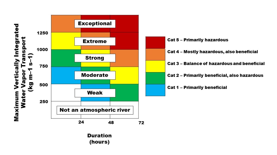
The scale helps scientists and the public quickly distinguish between these two allow for easy dissemination and understanding of whether or not it's a weak event bringing beneficial rain or a strong event delivering catastrophic impacts.
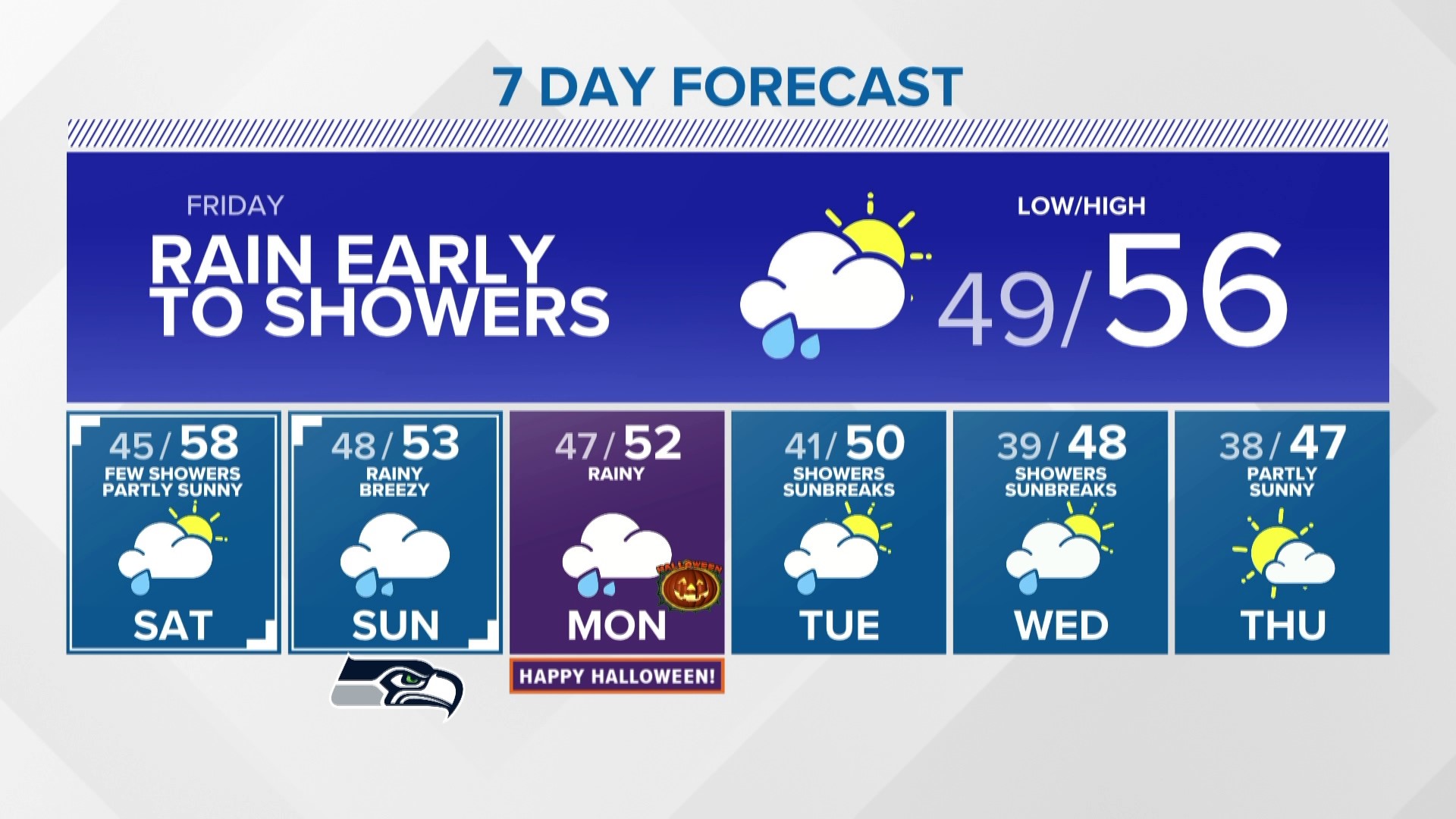
Weak atmospheric to impact parts of western Washington
There's the potential for two weak atmospheric river events to bring areas of moderate to heavy precipitation to parts of western Washington over the coming days.
The first system is diving down the coast of Canada and appears to coincide with a weak atmospheric river with the potential of a second weak atmospheric river later this weekend.
Thursday into early Friday
The first round of heavy rain associated with the first atmospheric river arrived Wednesday night for the far northwestern parts of Washington.
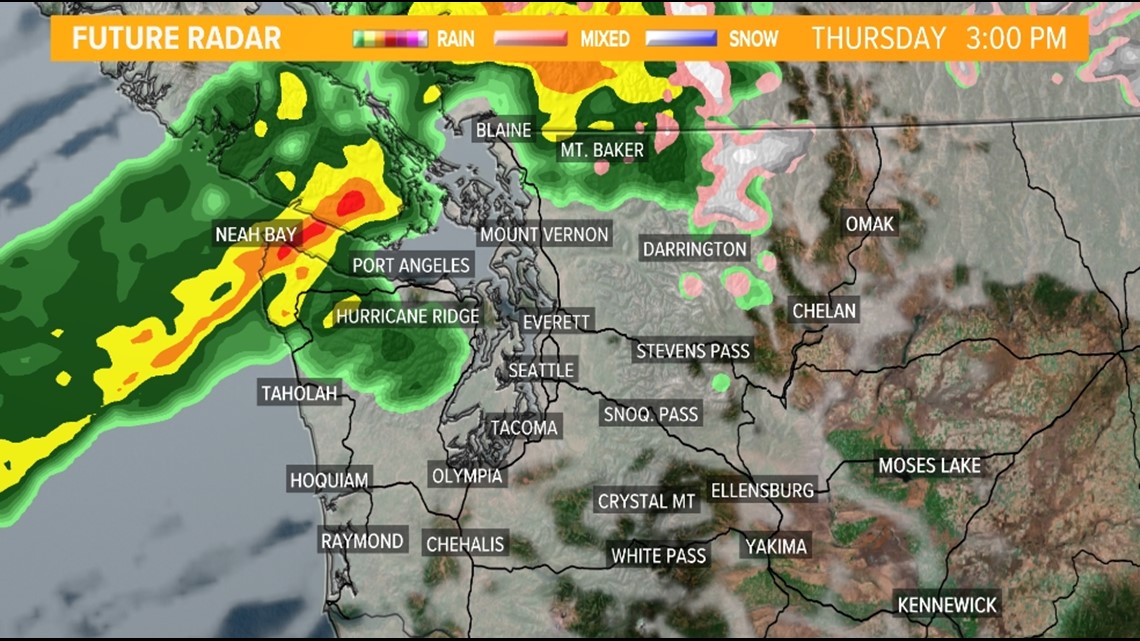
The northern tip of the Olympic Peninsula will see the moisture aimed at that area Thursday, slowly shifting south across the Olympic Peninsula into the Northwest Interior throughout the day on Thursday.
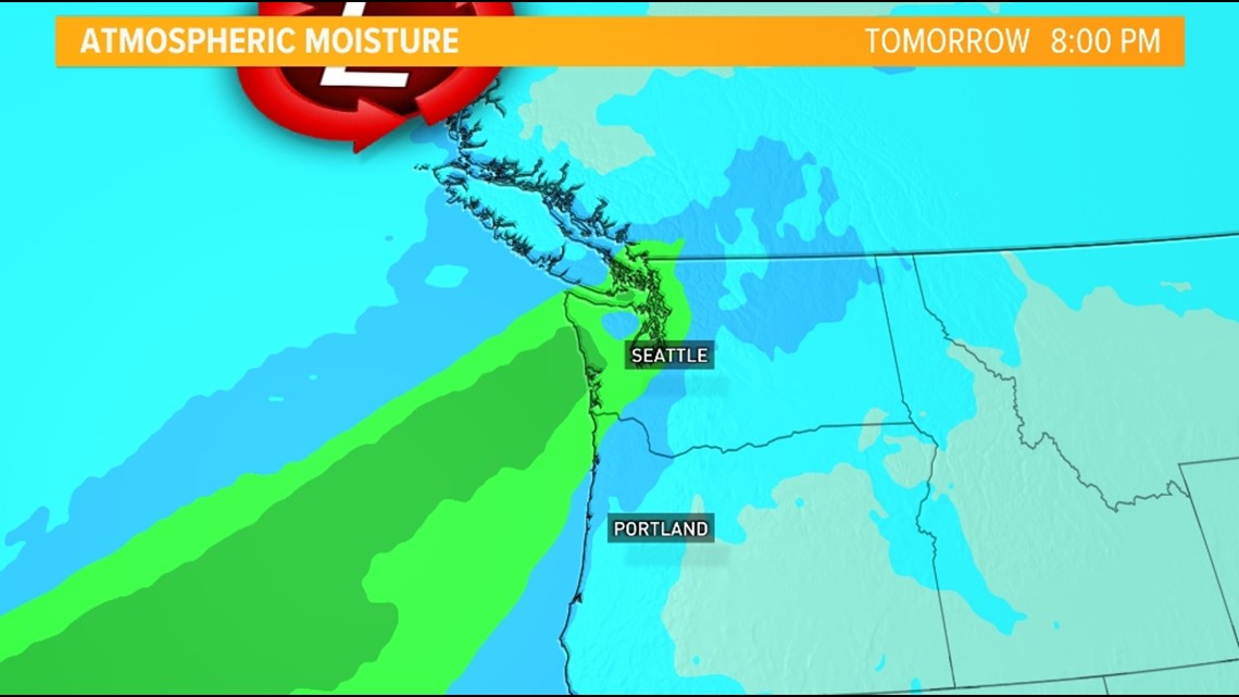
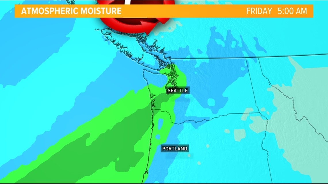
The band of precipitation will shift south and east into Puget Sound and the Southwest Interior overnight Thursday into Friday morning with the precipitation beginning to lessen in intensity as most of the rich atmospheric moisture looks to start to lessen so this means lighter precipitation amounts for Seattle and Everett.
Atmospheric moisture Thursday evening

Atmospheric moisture Friday morning

Snow levels will rise with this atmospheric river event as temperatures warm a few degrees with a higher content of moisture in the atmosphere. Snow levels are expected to rise from 3,500 feet to around 6,000 feet by Thursday night. This is above pass levels.
Future radar Thursday afternoon

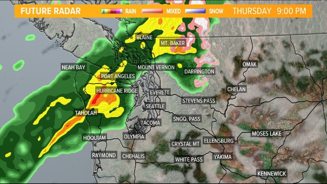
Future radar Thursday night

Future radar Friday morning

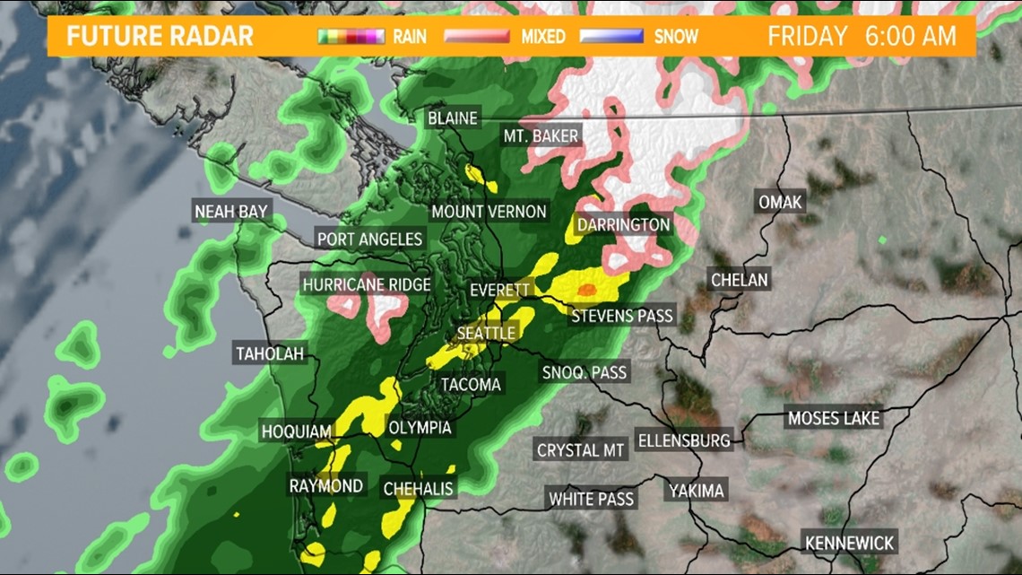
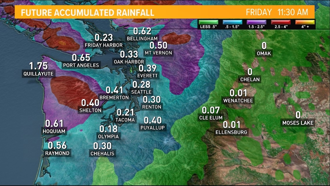
The heaviest rain accumulations are expected for the Olympic Peninsula and the Northwest Interior.
This is where 1-2 inches of rain will fall with isolated amounts of up to three inches. Farther south and east, including most of Puget Sound, will see lighter amounts generally less than 0.50 inches.
The flood risk at this time appears to be on the low end. However, minor nuisance flooding is possible along with minor flooding in urban areas and near creeks and streams. There's a higher flood risk near recent burn scars.
Rain accumulation is forecast through Friday morning

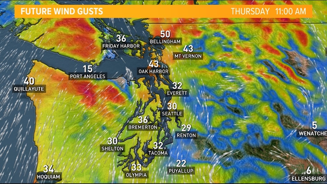
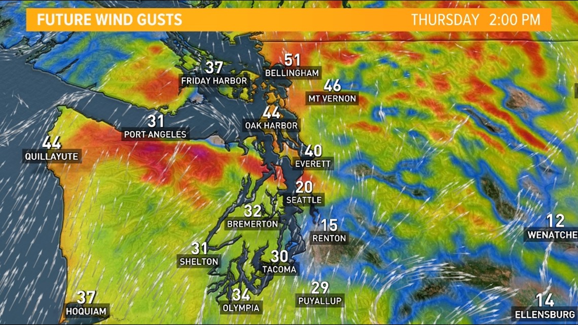
As the system approaches and sends a cold front into the area it will increase the winds. While not a true PNW windstorm, some high gusts up to 30 to 40 miles per hour are possible Thursday.
The strongest wind gusts are expected to favor the Pacific Coast communities, near the Strait, the San Juan Islands, and the Interior Northwest.
A couple of strong gusts are possible by Thursday early afternoon for Seattle and Everett possibly gusting up to 30 miles per hour.
Widespread power outages are not expected but a few isolated areas of power outages are possible where the strongest gusts occur. Keep in mind, trees still have foliage and are stressed from the long, dry, warm summer, making some of the branches more vulnerable and susceptible to coming down during higher wind gusts.
Thursday wind forecast
A Wind Advisory is in effect for several areas of western Washington on Thursday.
The National Weather Service (NWS) issued an advisory for the north coast until 5 p.m. Thursday, saying winds of 25-35 mph with gusts up to 45 mph are expected. The NWS said the advisory includes the cities of Beaver, Clearwater, Forks, La Push, Neah Bay, Ozette and Queets.
A Wind Advisory is also in effect for San Juan County and western Whatcom and Skagit counties until 8 p.m. Thursday, including Everett and the Admiralty Inlet area. Winds between 25-35 mph are expected, with gusts up to 50 mph.


This weekend
Another storm system arrives later this upcoming weekend.
This system is still several days out so there is lower confidence with specifics on the system but it does appear it'll have the potential to tap into another atmospheric river late Saturday into Sunday.
Atmospheric moisture Saturday afternoon

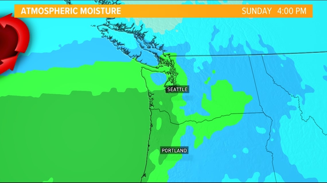
This setup could potentially bring another round of heavy precipitation and possibly another round of gusty winds.
Keep checking back for updates on this second system as the details become clearer.
Make sure you download the KING 5 App to get the latest weather alerts and forecasts.