
SEATAC, Wash. — After a three-day stretch of warm temperatures in the 70s and largely dry weather, the active weather pattern from April and May arrives again this weekend.
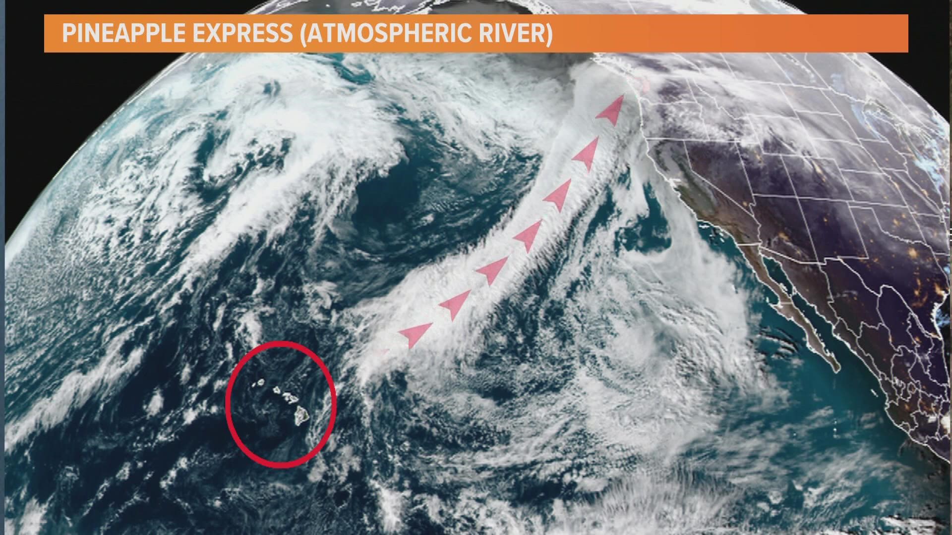
A strong upper area of low pressure near the Gulf of Alaska is spinning, rotating pieces of energy and associated frontal systems into western Washington. One of these fronts will bring rain chances to the area this weekend. By the end of the weekend, parts of western Washington could approach the average rainfall for the month of June within just 48 hours.
Download the KING 5 app to check the interactive radar near you, as well as the latest forecast, cameras and current conditions.
Timeline
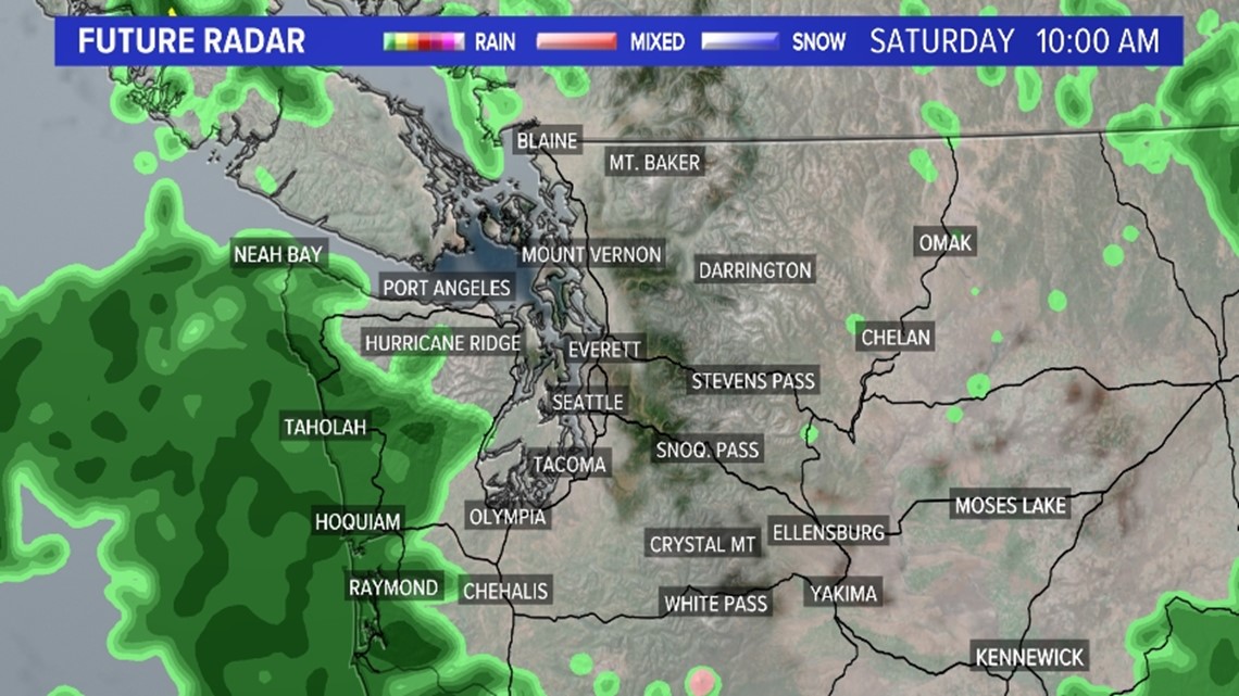
Saturday morning
Saturday morning will feature spotty showers for Puget Sound but largely Puget Sound will remain dry with even a sun break or two. The most widespread rain will be confined to the Coastal Beaches and parts of the Olympic Peninsula where the front is located.

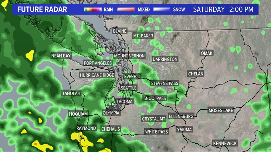
Saturday afternoon
The front is pushed farther into the state later in the day as a piece of energy from the upper area of low pressure rotates toward the Pacific Northwest. This will act to push the front closer to I-5 and increase rain chances for the Southwest Interior and eventually South and Central Puget Sound. Spotty rain showers are also possible elsewhere.

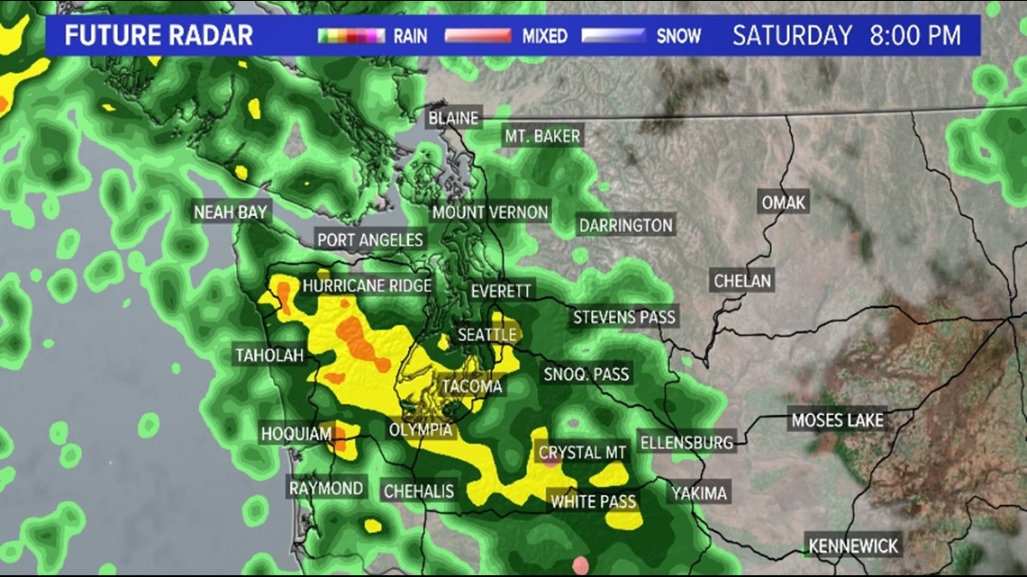
Saturday evening
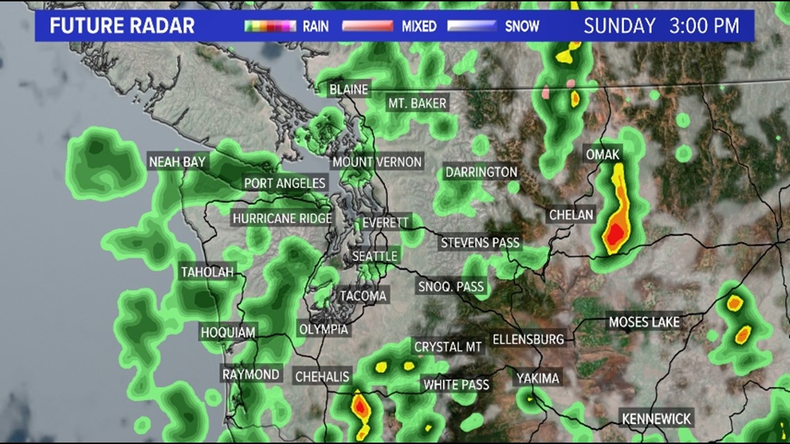
An area of consistent, moderate rainfall will establish itself across Puget Sound during the evening hours into the foothills, Cascades, and San Juan Islands. Farther west for the Coastal Beaches, the rain becomes spottier in nature by the evening hours. The rain chances stick around overnight into the predawn hours Sunday for Puget Sound.

Sunday
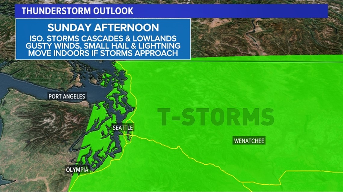
The cold front clears the region on Sunday leaving behind a more unstable airmass. Temperatures high in the atmosphere will be quite cold while the June sun breaks allow the surface to warm quickly. This temperature difference throughout the atmosphere will make it a touch unstable outside. This means spotty showers Sunday morning will turn into spotty thunderstorms Sunday afternoon.

The favored area to see thunderstorms is from Puget Sound east into the foothills and Cascades. Lightning is possible with any storm that develops. If you hear thunder or see lightning, move indoors.

Rain totals
Rain totals are expected to be impressive for areas this weekend. The weekend system will tap into a rich moisture plume that will move in from the Pacific. While the deepest moisture will be aimed at Oregon and northern California, the moisture tap will be quite impressive for June standards in western Washington.
With the rich moisture across the region paired with strong lift, expect areas of impressive rain totals given the time of year. While models have backed off on the heaviest totals over the past few days, models are still suggesting the possibility of areas seeing an inch or more of rain.
The favored areas to see 0.75-1 inch of rain this weekend are South Sound, Central Sound, the Hood Canal, and the Kitsap Peninsula. This includes Seattle, which could see just over 1 inch of rain. If this happens, that would be nearly the average precipitation for the entire month of June. June averages 1.45 inches of rain for the month of June in Seattle.

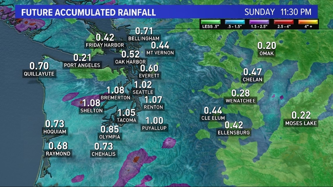
Lighter but still impressive totals are possible for North Sound, the Southwest Interior, and the Coastal Beaches where 0.50-0.75 inches could fall over the weekend. Due to the setup, the North Coast will be rain shadowed so lesser totals are possible there.
The flood risk is low with this event but if you live in a flood-prone area or near a river, be alert for changing conditions, especially with the combination of rain and snowmelt.
A look ahead shows direr and milder conditions for the first half of the upcoming workweek.