SEATTLE — A strong late-season storm system will bring big impacts to western Washington that will continue through Tuesday morning.
The system will be a bit of a one-two punch. Impacts arrived early Sunday for our coastal communities before spreading over the entire Olympic Peninsula, Puget Sound and the Cascades later in the day. Another round of impacts will be felt Monday into Tuesday morning.
Below is a timeline of what to expect:
Monday morning

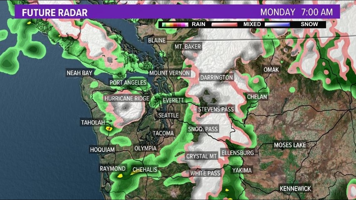
The aforementioned cold front will be the second "punch" of the system late Sunday into Monday with rain and snow continuing through the duration of the day. Snow levels will fall to around 2,000 feet behind the cold front along with gusty westerly winds up to 50 mph. Some higher gusts are possible for higher elevations and near gaps. Isolated thunderstorms are also possible Monday morning behind the cold front as the atmosphere becomes unstable. Thunderstorms will favor the coastal communities, the lowlands of the Olympic Peninsula and Puget Sound. The strongest storms could produce lightning, heavy rainfall, strong wind gusts, and hail up to pea size.
Monday afternoon

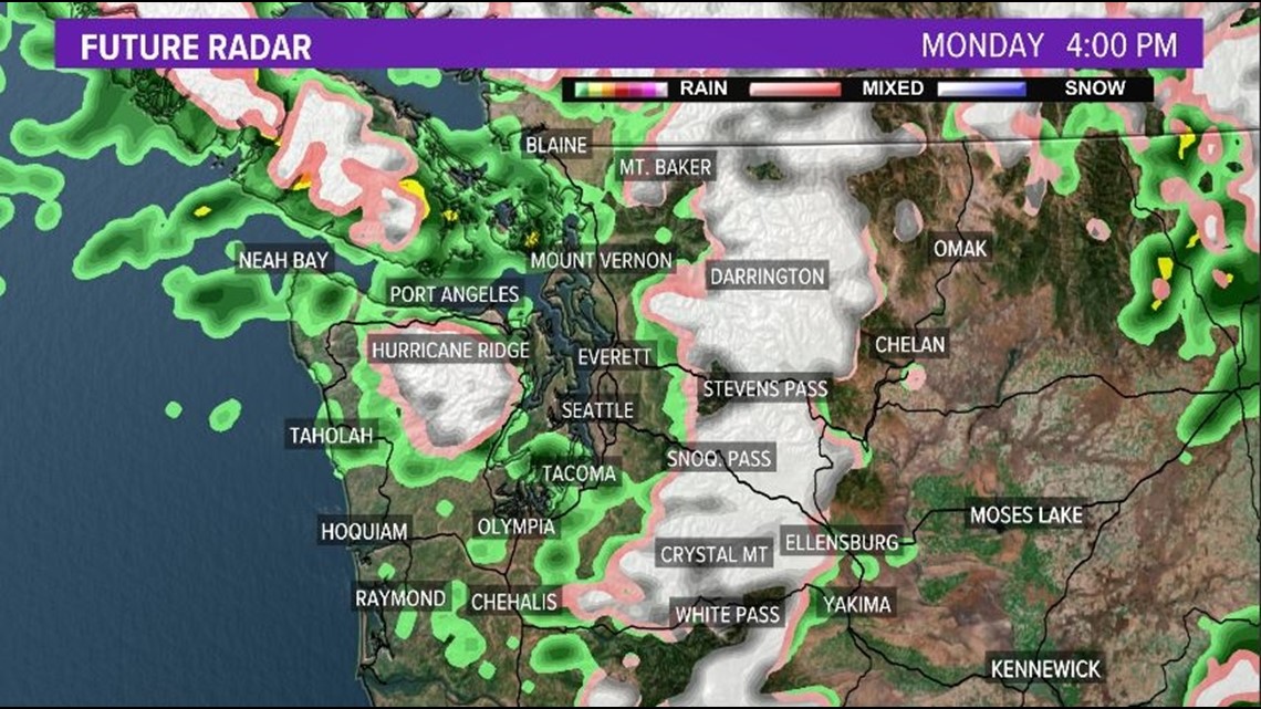
The rain and snow showers continue Monday afternoon with isolated thunderstorms beginning to decrease by late afternoon as the atmosphere becomes more stable. Heavy snow is expected for Snoqualmie and Stevens Passes. Travel is strongly discouraged especially later in the day on Monday. The strong gusty winds will also continue into the afternoon hours Monday behind the cold front.
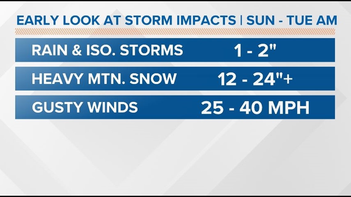
Storm system impacts
The expected impacts are moderate to heavy lowland rain along with isolated thunderstorms, heavy mountain snow above 2,500 feet, gusty winds around 50 mph, and large coastal waves.
Impacts
- Moderate to heavy rainfall
- 1-2 inches of lowland rain
- Isolated areas of flooding possible for urban areas and areas near the Kitsap Peninsula & Hood Canal
- Heavy mountain snow
- Snow levels fall to 2,000 feet late Monday
- 12-24+ inches
- Up to 40 inches for the highest mountains in the Cascades
- Dangerous pass travel
- Large coastal waves
- Around 10 feet with a few waves up to 25 feet
- Dangerous beach & boating conditions
- Strong wind gusts
- 40 mph
- Stronger gusts in gap areas and higher elevations
- Isolated thunderstorms
- Heavy rain
- Gusty winds
- Pea size hail
- Lightning

Rain forecast

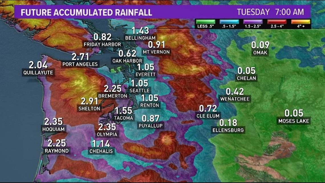
A widespread 1 inch of rain is expected Sunday through Tuesday morning for Puget Sound with heavier amounts of 2 + inches for the South Sound, Kitsap Peninsula, coastal communities, and lowlands of the Olympic Peninsula.
Snow forecast

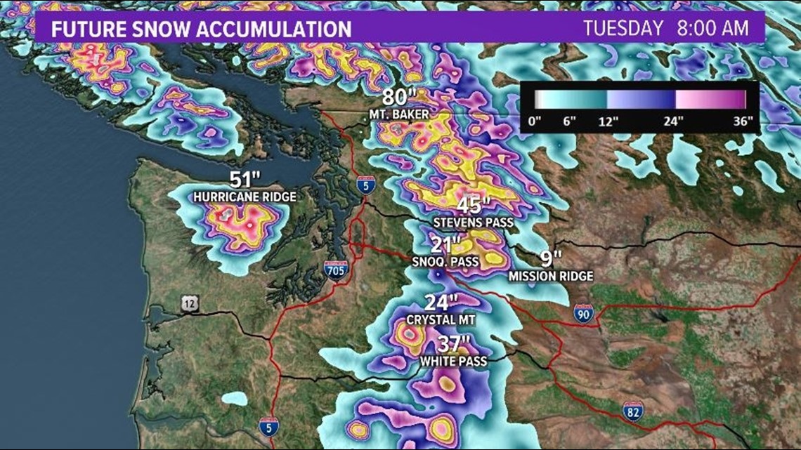
Heavy snow is expected for the Olympics & Cascades above 2,000 feet. This is where 12 to 24 + inches of snow is expected with the greatest amounts for the higher elevations. Snoqualmie Pass & Stevens Pass could well over a foot of snow with heavier snow amounts for Stevens Pass. Mt. Baker could see several feet of snow by the time this system departs western Washington.
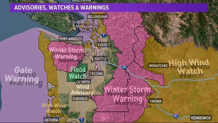
Latest advisories, watches, and warnings


Because of the high impacts from this system, a host of weather alerts have been issued for western Washington.
- Winter Storm Warning: Olympics & Cascades
- Sunday afternoon into early Tuesday morning
- 12 - 24 + inches of snow above 2,500 feet
- 30 40 inches for the highest peaks
- Flood Watch: in and around Mason County
- Sunday afternoon through Tuesday afternoon
- Flooding near creeks, rivers, streams, low-lying areas, and flood prone areas
- High Wind Watch: south Washington coast & east of Cascades
- Sunday evening through Monday
- Winds sustained at 30 - 40 mph with gusts up to 50 - 60 mph
- Wind Advisory: Southwest Interior & Puget Sound
- Monday
- Winds sustained at 25 - 35 mph with gusts up to 50 mph
If you live in a flood prone area, move to higher ground if water rises and never cross roadways covered by water. Travel is strongly discouraged along Interstate 90 and Highway 2 late Sunday through Tuesday. Check travel restrictions for Snoqualmie Pass and Stevens Pass.
RELATED: Western Washington Forecast