SEATTLE — Weather professionals and outdoor recreationists now have a new tool they can use to compare current and historical snow depths at nine different sites in the Pacific Northwest.
The new interactive website lets users compare measurements from nine monitoring sites in Washington and two in Oregon. It allows the user to compare the differences in mountain snow depth from one season to the next and create a graphic of their results.
The tool shows snow depth is a mixed bag at monitoring sites in Washington – five sites had above average snow depth at the beginning of February, including Crystal Mountain, Snoqualmie Pass and Mount Baker. Four sites had below average snow depth, including Paradise at Mount Rainier, Stevens Pass and White Pass.
“This is a tool that people in the weather community, like meteorologists and climatologists, as well as snow recreationalists, can use to communicate the current snow conditions and how they relate to average conditions and previous years,” said Karin Bumbaco, a UW research scientist.

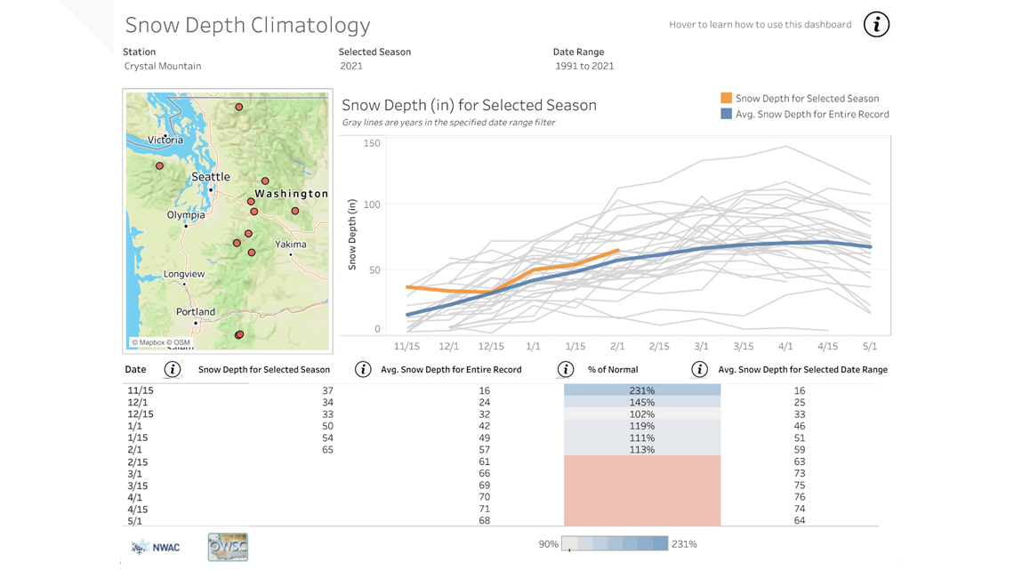
The Northwest Avalanche Center monitors snow depths to help track the avalanche risks facing roadways and people entering the backcountry. Their data is entered 12 times a year on the first and the 15th of each month, during the monitoring season from Nov. 15 to May 1.
“We use this tool to track how our snow depth is building across NWAC’s forecast region in a historical context,” said Dennis D’Amico, meteorologist and forecast director at the Northwest Avalanche Center, who worked on the project. “Local professionals and recreationists track this report all season long. This new tool will allow them to explore historical snow depth data in a modern visualization tool at winter recreation access points.”
The tool is the result of a collaboration between the University of Washington and the Northwest Avalanche Center and it's available for free on the Office of the Washington State Climatologist's website.